Free Ordnance Survey Maps
Categories: Navigation
UPDATE: Oct 2011 streetmap.co.uk also have the 25K series maps
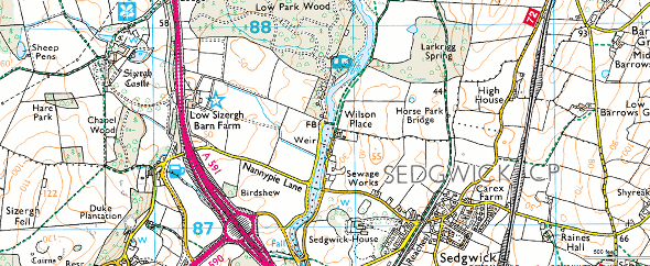
For outdoor activities such as walking and hiking, the maps that are the most useful in the UK, (and most widely available) are the Ordnance Survey 1:25000 series. These 2.5inches to 1mile scale are the best when it comes to looking for rights of way, or checking the contours of a mountain for route finding. Despite having a small collection of such maps, there will always be occasions when you only need a small section, or you just don’t have the required map in your possession.
Although this mapping has become available on a variety of online mapping services, the best I’ve found so far is Bing, due to fact the window size isn’t restricted, and you can hide the left hand menu.
Creating Maps from Bing
It’s pretty easy to maximise the browser, hide the left hand nav, zoom in the maximum-1 level (you don’t get more detail at max zoom, just bigger pixels), then take a screen grab. (Vista/Win7 Snipping Tool, download Snippy if you’re using XP, or just hit the PrtScr keyboard button if you’re prepared to do some cropping) you could now paste that image into Photoshop or the GIMP{#hm:i}, and print, making sure you scale to fit the page. however, I like to have the map printed off at the correct scale, and to do this, you need to adjust the pixels/cm settings of the image.
Determining the scale for printing (in a rush? use 9.02pixels/mm)
- I measured a real map to get the horizontal size of a single OS grid. On a map I had, each grid was 39.8mm wide on the map. I thought they were supposed to be 40mm, or 1km, but as I don’t know exactly how the grid is projected, it may be that the grids vary depending on where in the country you are. This is why I measured from a paper map which was geographically near to the one I wanted to print - just in case. If you don’t have a map to hand, I’m sure the 39.8mm measurement will do just fine.
- Take a screen grab of the area you want using Bing maps. Ensure you are in OS map mode, and zoomed into maximum-1 using the zoom buttons (not the slider). Any further out and you’ll get the 1:50000 mapping. Obviously a bigger monitor is better. A full screen 24” monitor @ 1920x1200 only produced a map 225mm wide without stitching them together. I used Vista/Win7’s Snipping Tool to cut out the screen section I wanted and then copy to clipboard. The free ‘Snippy{#cxkh}’ tool is god for XP. Mac and Linux users - you’ll figure it out!
- Using GIMP, File -> Create -> From Clipboard to paste the map into a new document
- File -> Page Setup if you need to switch to landscape mode
- Measure the width of a single grid using the rectangle selection tool. (zoom to 100% and ensure measuring units are pixels). In my example, a grid was 359 pixels wide.
- Calculate the pixels/mm. In my example 359px / 39.8mm = 9.02px/mm
- Set this value in Image -> Print Size… X Resolution (Y Resolution changes automatically)
- Save if you like, and print your scale map
Printing the maps (Gimp)
Even though you may have set the pixels/mm setting, GIMP will ignore this when you some to print the document.
- File -> Print -> Image Settings… change back to 9.02pixels/mm
- If Gimp changes this to a higher value, it means that Gimp is scaling the image to fit the paper size, instead of cropping the image
- Go back and crop the image so it fits your paper size, and try again
For larger maps, use layers to make stitching together the separate screen grabs easier.
When out and about, I use one of those A4 transparent pockets used in presentation folders. I keep meaning to try out waterproof inkjet paper. I suspect it’ll take more ink with less bleeding than standard copier paper. Photo paper produces great results, but your map is like cardboard!
Now get out there and enjoy the outdoors!
Comments